
BlackRock launches STAR ETF tracking space technology stocks
BlackRock has launched the iShares Space Technologies UCITS ETF, giving UK and European investors listed exposure to space companies. BlackRock said the fund trades under the ticker STAR and tracks the STOXX Global Space Satellites and Drones Index. The product…
By Irene Mukiri 6/9/2026, 2:14:03 PM
A16z, Paradigm lead $175 million bet to move global credit markets onchain
Morpho secured $175 million from Paradigm, a16z crypto and Ribbit as the lending protocol seeks to become foundational infrastructure for onchain credit markets.
By Jamie Crawley 6/9/2026, 2:07:32 PM

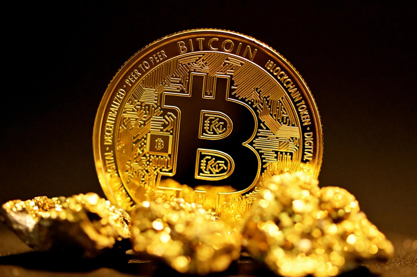
Why Didn’t Bitcoin Go Higher? Arthur Hayes Blames the AI Spending Frenzy
Hayes believes that AI's growing demand for capital has become a major headwind for bitcoin.
By Chayanika Deka 6/9/2026, 2:03:55 PM

Tim Scott says Clarity Act makes Bitcoin safer and more transparent
The Clarity Act could position the US as a global crypto leader by providing regulatory certainty, fostering innovation, and enhancing investor protection. The post Tim Scott says Clarity Act makes Bitcoin safer and more transparent appeared first on Crypto Briefing.
By Editorial Team 6/9/2026, 2:03:28 PM

Sportradar signs multi-year deal with Kalshi for official sports data
This deal could reshape sports betting by integrating prediction markets, enhancing data accuracy, and expanding market reach globally. The post Sportradar signs multi-year deal with Kalshi for official sports data appeared first on Crypto Briefing.
By Editorial Team 6/9/2026, 2:01:26 PM
Donald Trump, Benjamin Netanyahu discuss ceasefire in phone call as Bitcoin drops to $63K
Geopolitical tensions impact global markets, highlighting the fragile balance between diplomacy and economic stability amid fluctuating crypto values. The post Donald Trump, Benjamin Netanyahu discuss ceasefire in phone call as Bitcoin drops to $63K appeared first on Crypto Briefing.
By Editorial Team 6/9/2026, 2:01:13 PM

Privacy push as StarkWare and Sui move toward compliance-ready confidential transfers
StarkWare and Sui roll out confidential transfer systems as Zama boosts compliance efforts and Zcash’s Orchard bug highlights risks in shielded privacy models.
By Christina Comben 6/9/2026, 2:01:11 PM

Equity Bull Market ‘Still Intact and in Very Good Shape,’ Says Fundstrat’s Tom Lee – Here’s Why
Fundstrat managing partner Tom Lee says last week’s stock market pullback is a “false narrative” about the health of the bull market — and he is urging investors not to read too much into the volatility. Lee, a CNBC contributor, made the remarks Monday on “Power Lunch” after markets sold off sharply Friday before rebounding […] The post Equity...
By Daily Hodl Staff 6/9/2026, 2:00:42 PM

US missile strike on Marivex escalates tensions in Strait of Hormuz
The missile strike heightens geopolitical instability, potentially disrupting global oil supply chains and impacting energy markets significantly. The post US missile strike on Marivex escalates tensions in Strait of Hormuz appeared first on Crypto Briefing.
By Estefano Gomez 6/9/2026, 1:52:56 PM
Humanity Crypto Exploited for $32M in Latest DeFi Hack
Humanity Protocol's H token crashed up to 90% after attackers stole private keys and drained over $32M. Here's what the price data shows and what comes next. The post Humanity Crypto Exploited for $32M in Latest DeFi Hack appeared first on Coinspeaker.
By Daniel Francis 6/9/2026, 1:48:16 PM
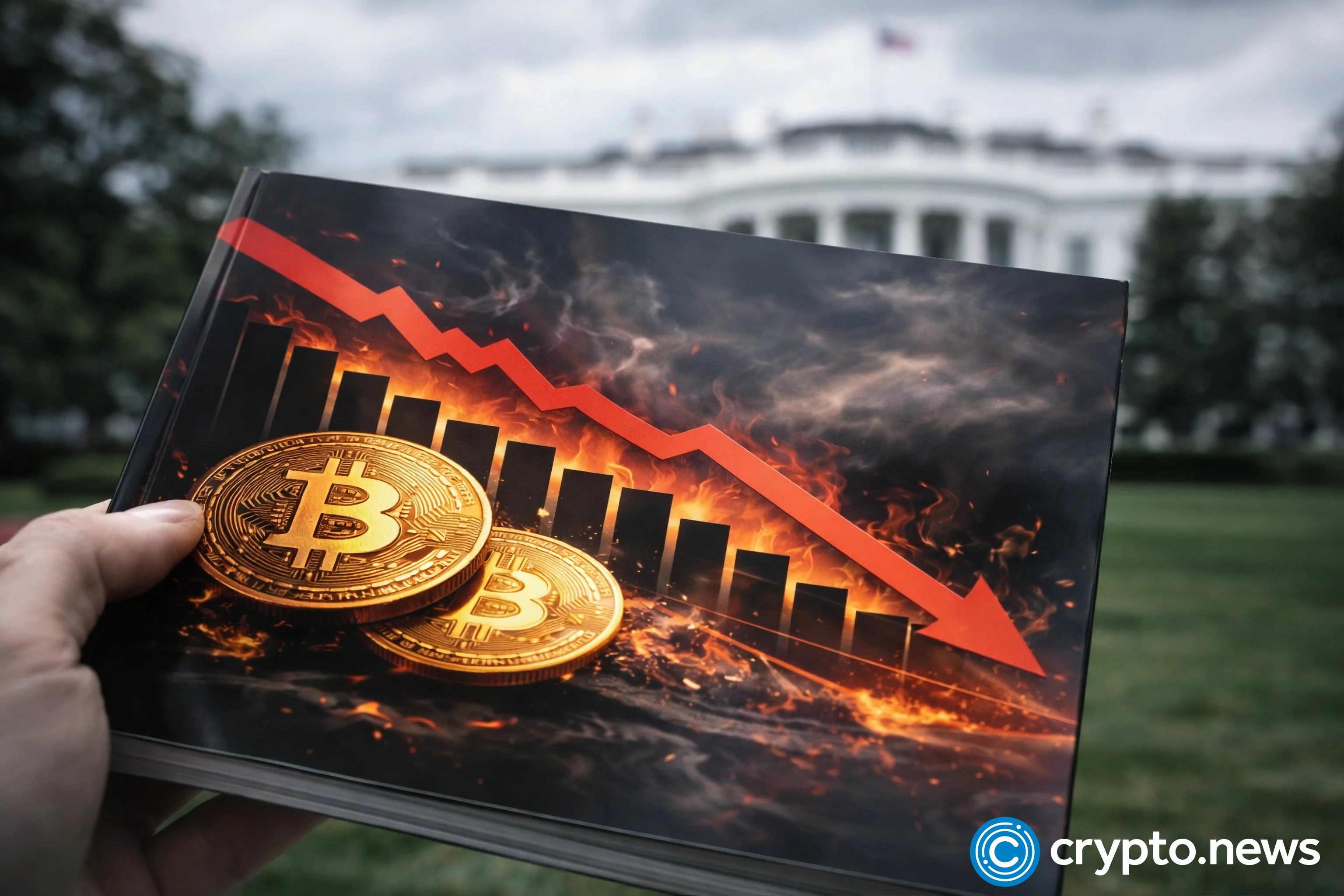
Bitcoin’s $10 billion liquidation wave reveals why the AI boom is hurting crypto
Bitcoin’s drop toward $60,000 last week exposed how quickly a shift in investor appetite can turn into forced selling when leverage has been rebuilt beneath the surface of the crypto market. The largest cryptocurrency by market value fell nearly 14% last week, triggering almost $10 billion in liquidations of long futures as traders who had […] The...
By Oluwapelumi Adejumo 6/9/2026, 1:45:36 PM
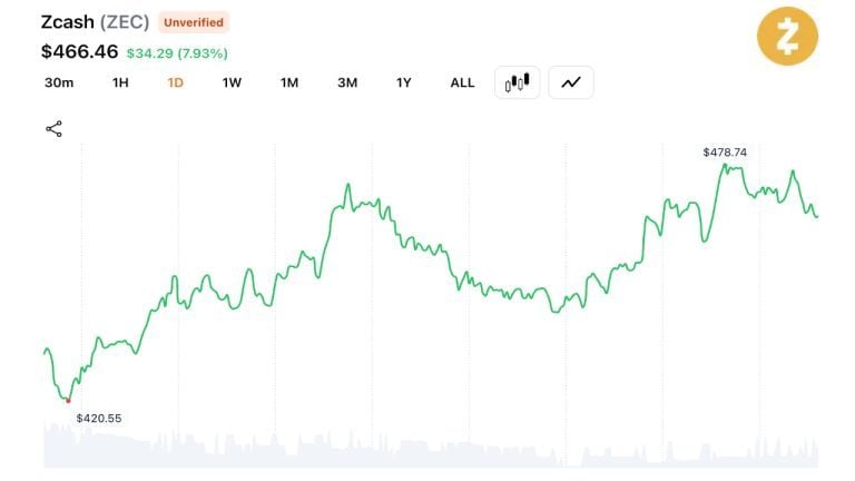
Zcash Climbs 80% Since June 5 as Traders Shrug off Orchard Bug Fears
Zcash jumped 11.3% to $478, marking an approximate 80% recovery since its June 5 plunge. The rally pushed its market capitalization back above $8 billion and wiped out $11.5 million in short positions. The Orchard Vulnerability Privacy coin Zcash (ZEC) surged on Tuesday, jumping 11.3% to $478 as it maintained a steady recovery that began […]
By Terence Zimwara 6/9/2026, 1:44:25 PM

4 memecoins to watch as Dogecoin remains primed to hit $0.50 in 2026
Memecoin activity stays strong as Dogecoin, MemeCore, and Little Pepe draw investor attention in 2026. There is no time for the memecoin market to rest, is there? Having had an eventful start to 2026, a few memecoins have managed to…
By Samuel Msiska 6/9/2026, 1:41:08 PM

Trump announces imminent Middle East ceasefire amid weekend hostilities
The announcement signals potential diplomatic progress but highlights the complexity of achieving lasting peace amid ongoing regional tensions. The post Trump announces imminent Middle East ceasefire amid weekend hostilities appeared first on Crypto Briefing.
By Estefano Gomez 6/9/2026, 1:38:37 PM

Strive buys 32 Bitcoin for $2.1M, pushing total holdings to 19,032 BTC
Strive's growing Bitcoin holdings amplify its market influence, tying its stock performance closely to Bitcoin's volatile price dynamics. The post Strive buys 32 Bitcoin for $2.1M, pushing total holdings to 19,032 BTC appeared first on Crypto Briefing.
By Editorial Team 6/9/2026, 1:36:47 PM

Iran halts military operations against Israel amid peace efforts, Bitcoin stabilizes after volatility spike
The de-escalation may foster diplomatic progress in nuclear talks, potentially reducing geopolitical risks and stabilizing global markets. The post Iran halts military operations against Israel amid peace efforts, Bitcoin stabilizes after volatility spike appeared first on Crypto Briefing.
By Editorial Team 6/9/2026, 1:36:30 PM

Nvidia partners with LG to build humanoid robots and next-generation data centers
This partnership could redefine AI's role in real-world applications, enhancing Nvidia's market reach and solidifying its tech ecosystem dominance. The post Nvidia partners with LG to build humanoid robots and next-generation data centers appeared first on Crypto Briefing.
By Editorial Team 6/9/2026, 1:36:08 PM

SpaceX IPO poised to exceed $1T market cap amid strategic shifts
SpaceX's IPO could redefine market dynamics, enhancing its geopolitical influence and expanding its role in tech and defense sectors. The post SpaceX IPO poised to exceed $1T market cap amid strategic shifts appeared first on Crypto Briefing.
By Estefano Gomez 6/9/2026, 1:32:53 PM
‘Bitcoin to zero’ searches just hit a record. Could it happen?
U.S. searches for “Bitcoin to zero” hit a record high amid the crash. Could it happen? The real scenarios, why each is improbable, and what fear signals.
By Olivia Stephanie 6/9/2026, 1:30:00 PM
Here’s XRP Worst-Case Bottom Price for June Based on Historical Midterm Year Patterns
EGRAG Crypto, one of the most prominent analysts on crypto Twitter, has identified the bottom price for XRP this June in its worst-case-scenario crash. According to EGRAG, the ongoing market downtrend has still not reached its lowest level for this month. Visit Website
By Mark Brennan 6/9/2026, 1:26:32 PM

China Plans $295 Billion AI Infrastructure Push Centered on Domestic Chips
The post China Plans $295 Billion AI Infrastructure Push Centered on Domestic Chips appeared first on Coinpedia Fintech News China has announced plans to build a nationwide AI data center network over the next five years, with state-owned telecom operators leading the project and domestic suppliers expected to provide at least 80% of AI chips. The...
By Qadir AK 6/9/2026, 1:25:28 PM

Bancor’s Stablecoin Fee Vote: Can Lower Costs Revive BNT’s DeFi Relevance?
0.001% stablecoin taker fee on Bancor’s Carbon aims to attract routers as TVL holds near $24.76M and 30‑day fees ≈ $31.5K. Can lower costs lift BNT’s role?
By Sophia Bennett 6/9/2026, 1:21:32 PM
Binance to Remove 7 Spot Trading Pairs Including ADA/BNB and Midnight Pair
The seven crypto trading pairs affected are paired against BNB, BTC, ETH, and USDC.
By Tomiwabold Olajide 6/9/2026, 1:20:40 PM

Pundit Accuses “XRP Team” of Causing Massive Losses Among Korean Traders
Amid the recent XRP price decline, a crypto trader and commentator has called attention to losses suffered by traders in South Korea. Notably, market pundit Ryker accused the "XRP team" of contributing to major losses among South Korean investors through promotional efforts. Visit Website
By Mark Brennan 6/9/2026, 1:19:21 PM
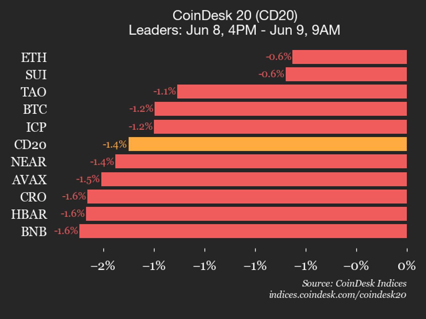
CoinDesk 20 performance update: AAVE Drops 2.6% as all constituents trade lower
Uniswap (UNI), down 2.9% from Monday, joined Aave (AAVE) as an underperformer.
By CoinDesk Indices 6/9/2026, 1:16:44 PM

Bending Spoons files for US IPO as sales surge past $600M in Q1
Bending Spoons' IPO could accelerate its acquisition strategy, potentially reshaping the tech landscape and influencing market valuations. The post Bending Spoons files for US IPO as sales surge past $600M in Q1 appeared first on Crypto Briefing.
By Editorial Team 6/9/2026, 1:13:11 PM

Gold falls to two-month low as strong US jobs data boosts rate-hike bets
Rising US rate-hike expectations could shift investments from non-yielding assets like gold and crypto to higher-yielding alternatives. The post Gold falls to two-month low as strong US jobs data boosts rate-hike bets appeared first on Crypto Briefing.
By Editorial Team 6/9/2026, 1:11:32 PM

Meta files contempt complaint against NSO Group for violating court order on WhatsApp targeting
Meta's legal action against NSO Group underscores the ongoing challenges in enforcing digital privacy protections and deterring spyware misuse. The post Meta files contempt complaint against NSO Group for violating court order on WhatsApp targeting appeared first on Crypto Briefing.
By Editorial Team 6/9/2026, 1:11:06 PM

Starknet launches STRK20 privacy for every ERC-20 token
Starknet launches STRK20, enabling private ERC-20 balances and transfers with viewing keys for lawful, targeted disclosure across DeFi apps.
By Olivia Stephanie 6/9/2026, 1:10:00 PM

XRP Is Approaching Its Best Buying Zone in 8 Years: Analyst Maps Out Ripple’s Path to $3
If that 8-year resistance falls, the token token could be heading toward double-digit price levels.
By Jordan Lyanchev 6/9/2026, 1:09:47 PM
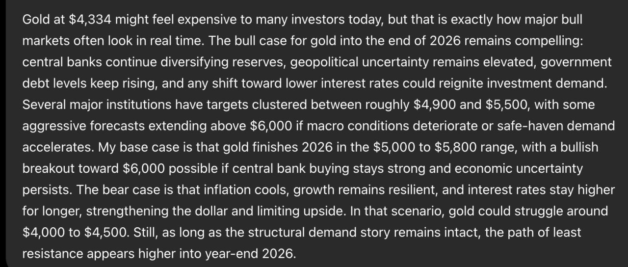
Sam Altman ChatGPT AI Predicts Surprising Gold Price by End of 2026
Sam Altman ChatGPT AI predicts that the gold price is pushing into the $5,000 to $5,800 range by the end of 2026. With gold trading near $4,334 right now, that price target targets a steady grind higher of roughly 15% to 34% on a metal that already feels expensive to a lot of people. The […] The post Sam Altman ChatGPT AI Predicts Surprising Gold...
By Daniel Francis 6/9/2026, 1:07:28 PM

Reading a Regional Media Market With the Outset Media Index Before You Expand
How to read a regional crypto media market with Outset Media Index before you expand. Why a new market's media structure breaks home-market assumptions, and the three reads that de-risk entry.
By Crypto Daily 6/9/2026, 1:05:18 PM

SBI Holdings unit to let depositors earn Bitcoin, Ether or XRP on top of yen interest
This initiative could accelerate mainstream crypto adoption, influencing financial institutions to integrate digital assets with traditional banking. The post SBI Holdings unit to let depositors earn Bitcoin, Ether or XRP on top of yen interest appeared first on Crypto Briefing.
By Vivian Nguyen 6/9/2026, 1:03:49 PM

Neura Closes Strategic Funding Round and Partnerships to Build Emotional AI with Persistent, User-Owned Memory
Neura Closes Strategic Funding Round and Partnerships to Build Emotional AI with Persistent, User-Owned Memory
By Chainwire 6/9/2026, 1:02:54 PM
Bitcoin inflows slow sharply in 2026 as investors chase AI, Bernstein says
Bernstein said bitcoin's increasingly diversified ownership base supports its long-term store-of-value thesis.
By Will Canny 6/9/2026, 1:02:48 PM

Not $60,000: Analyst Reveals The Best Time To Actually Start Buying Bitcoin
Bitcoin’s crash over the weekend has brought the $60,000 level back into the market conversation, but crypto analyst Merlijn The Trader believes the real opportunity may come at a lower price. Technical analysis comparing the current Bitcoin structure with the 2022 Wyckoff accumulation phase shows that buying the current bounce would be a costly...
By Sandra White 6/9/2026, 1:00:55 PM

DefiHash Showcases the Potential of AI Computing in Digital Finance
The post DefiHash Showcases the Potential of AI Computing in Digital Finance appeared first on Coinpedia Fintech News In the era of digital finance, many people are seeking new investment opportunities. Some deposit $3,000 in a bank and see almost nothing after a year; others rely on emotions and intuition to invest, only to suffer repeated losses...
By PR Manager 6/9/2026, 1:00:14 PM

Ripple’s David Schwartz explains his XRPL role in verse
David Schwartz answered a CTO emeritus jab with an XRP Ledger poem covering payments, custody, tokenization, DeFi and his 15-year role on X.
By Olivia Stephanie 6/9/2026, 1:00:00 PM

Second Launches Bark on Bitcoin Mainnet, Targeting Self-Custody UX Gap
Bitcoin Magazine Second Launches Bark on Bitcoin Mainnet, Targeting Self-Custody UX Gap Second has officially launched Bark — its implementation of the Ark protocol — on the Bitcoin mainnet. This post Second Launches Bark on Bitcoin Mainnet, Targeting Self-Custody UX Gap first appeared on Bitcoin Magazine and is written by Micah Zimmerman.
By Micah Zimmerman 6/9/2026, 12:59:24 PM

BlackRock warns of energy shock as May CPI is set to show acceleration in inflation
BlackRock is closely watching Wednesday's CPI as an early test of how U.S.-Iran tensions are feeding into already elevated prices in the economy.
By Omkar Godbole 6/9/2026, 12:58:09 PM
Arbitrum (ARB) Coin Price Prediction 2026, 2027 – 2030: Will ARB Hit $6 by 2030?
The post Arbitrum (ARB) Coin Price Prediction 2026, 2027 – 2030: Will ARB Hit $6 by 2030? appeared first on Coinpedia Fintech News Story Highlights The live price of the ARB token is . Price predictions for 2026 range from $0.70 to $1.20. ARB could extend toward $6 by 2030, if recovery structure holds. Arbitrum (ARB), one of the leading Layer-2...
By Shubham Vishwakarma 6/9/2026, 12:57:52 PM
Japanese Bank Chooses XRP as Part of New Campaign; Bollinger Bands Keep $90,000 Bitcoin Prediction in Play; 224 Billion Shiba Inu (SHIB) Go Online as 2024 Whale Reawakens - Morning Crypto Report
SBI Shinsei Bank offers XRP bonuses, Bollinger Bands see Bitcoin hitting $90,000 in a bear rebound, and a Shiba Inu coin whale from 2024 moves 224 billion SHIB.
By Gamza Khanzadaev 6/9/2026, 12:57:30 PM
ETHGas (GWEI) Hits a New ATH, But Why Is Trading Volume Falling as Price Rises?
The post ETHGas (GWEI) Hits a New ATH, But Why Is Trading Volume Falling as Price Rises? appeared first on Coinpedia Fintech News ETHGas (GWEI) price has emerged as one of the best-performing tokens in the crypto market, climbing to a fresh all-time high near $0.18 and breaking into the top 100 by market capitalization. While the token continues...
By Sahana Vibhute 6/9/2026, 12:57:11 PM

Ethereum DeFi Protocol That Just Raised $175 Million From a16z And Paradigm Has A Bold Message For Wall Street
Morpho, a decentralized lending protocol operating on Ethereum, HyperEVM, and other blockchains currently holding $6.6 billion in total value locked, has raised $175 million in a funding round led by Paradigm, Ribbit Capital, and Andreessen Horowitz’s digital assets arm a16z crypto — valuing the protocol at up to $2 billion and positioning it for...
By James Halver 6/9/2026, 12:56:11 PM
Ethereum Price Just Entered a ‘High Conviction’ Buy Zone — Here’s Why Long-Term Buyers Are Watching
The post Ethereum Price Just Entered a ‘High Conviction’ Buy Zone — Here’s Why Long-Term Buyers Are Watching appeared first on Coinpedia Fintech News Ethereum’s price crash has left traders nervous, but beneath the panic, a different story may be unfolding. ETH has now entered a rare “high conviction” zone for long-term buyers, according to market...
By Shubham Vishwakarma 6/9/2026, 12:52:17 PM

Live updates: bitcoin drifts back to $62,500, putting damper on hope for two straight up days
Crypto prices rose on Monday following last week's crash, but the bears still appear to be in control.
By Stephen Alpher 6/9/2026, 12:52:07 PM
Trump says US will maintain blockade of Iranian ports until deal reached
The prolonged blockade risks escalating economic instability, impacting global oil markets and cryptocurrency valuations, while straining US-Iran relations. The post Trump says US will maintain blockade of Iranian ports until deal reached appeared first on Crypto Briefing.
By Editorial Team 6/9/2026, 12:48:29 PM

Iran ends military operations against Israel, warns of harsher retaliation if Lebanon is attacked
Iran's warning highlights the fragile balance in Middle East geopolitics, with potential for broader regional conflict impacting global stability. The post Iran ends military operations against Israel, warns of harsher retaliation if Lebanon is attacked appeared first on Crypto Briefing.
By Editorial Team 6/9/2026, 12:48:18 PM

Israel strikes Tyre as cease-fire with Lebanon falters
The faltering cease-fire exacerbates regional instability, diminishing prospects for peace and increasing the risk of broader military conflicts. The post Israel strikes Tyre as cease-fire with Lebanon falters appeared first on Crypto Briefing.
By Estefano Gomez 6/9/2026, 12:41:36 PM

Is retail coming back to crypto? What the search data says
Bitcoin searches hit 12-month highs and analysts say retail is back. But on-chain data shows retail selling while whales buy. What the search data really means.
By Olivia Stephanie 6/9/2026, 12:40:00 PM